Flagstaff Market
 Flagstaff is a city located in northern Arizona, in the southwestern United States. In 2013, the city’s estimated population was 68,667. The combined metropolitan area of Flagstaff has an estimated population 136,539. It is the county seat of Coconino County. The city is named after a Ponderosa Pine flagpole made by a scouting party from Boston (known as the “Second Boston Party”) to celebrate the United States Centennial on July 4, 1876.
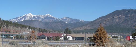
Flagstaff lies near the southwestern edge of the Colorado Plateau, along the western side of the largest contiguous Ponderosa Pine forest in the continental United States. Flagstaff is located adjacent to Mount Elden, just south of the San Francisco Peaks, the highest mountain range in the state of Arizona. Humphreys Peak, the highest point in Arizona at 12,633 feet (3,851 m), is located about 10 miles (16 km) north of Flagstaff in Kachina Peaks Wilderness.
Flagstaff’s early economy was based on the lumber, railroad, and ranching industries. Today, the city remains an important distribution hub for companies such as Nestlé Purina PetCare and Walgreens, and is home to Lowell Observatory, The U.S. Naval Observatory, the United States Geological Survey Flagstaff Station, and Northern Arizona University. Flagstaff has a strong tourism sector, due to its proximity to Grand Canyon National Park, Oak Creek Canyon, the Arizona Snowbowl, Meteor Crater, and historic Route 66. The city is also a center for medical device manufacturing, since Flagstaff is home to W. L. Gore and Associates.
History
In 1855, Lieutenant Edward Fitzgerald Beale surveyed a road from the Rio Grande in New Mexico to Fort Tejon in California, and camped near the current location of Flagstaff. The lieutenant had his men cut the limbs from a straight Ponderosa Pine tree in order to fly the United States flag.
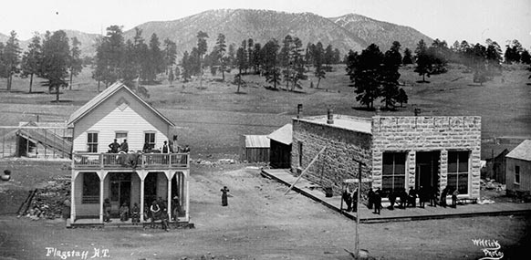
The first permanent settlement was in 1876, when Thomas F. McMillan built a cabin at the base of Mars Hill on the west side of town. During the 1880s, Flagstaff began to grow, opening its first post office and attracting the railroad industry. The early economy was based on timber, sheep, and cattle. By 1886, Flagstaff was the largest city on the railroad line between Albuquerque and the west coast of the United States. A ca. 1900 diary entry by journalist Sharlot Hall described the houses in the city at the time as a “third rate mining camp”, with unkempt air and high prices of available goods.
In 1894, Massachusetts astronomer Percival Lowell hired A. E. Douglass to scout an ideal site for a new observatory. Douglass, impressed by Flagstaff’s elevation, named it as an ideal location for the now famous Lowell Observatory, saying: “other things being equal, the higher we can get the better”. Two years later, the specially designed 24-inch (610 mm) Clark telescope that Lowell had ordered was installed. In 1930, Pluto was discovered using one of the observatory’s telescopes. In 1955 the U.S. Naval Observatory joined the growing astronomical presence, and established the United States Naval Observatory Flagstaff Station, where Pluto’s satellite, Charon, was discovered in 1978.
During the Apollo program in the 1960s, the Clark Telescope was used to map the moon for the lunar expeditions, enabling the mission planners to choose a safe landing site for the lunar modules. In homage to the city’s importance in the field of astronomy, asteroid 2118 Flagstaff is named for the city, and 6582 Flag symphony for the Flagstaff Symphony Orchestra.
 The Northern Arizona Normal School was established in 1899, renamed Northern Arizona University in 1966. Flagstaff’s cultural history received a significant boost on April 11, 1899, when the Flagstaff Symphony made its concert debut at Babbitt’s Opera House. The orchestra continues today as the Flagstaff Symphony Orchestra, with its primary venue at the Ardrey Auditorium on the campus of Northern Arizona University.
The city grew rapidly, primarily attributable to its location along the east-west transcontinental railroad line in the United States. In the 1880s, the railroads purchased land in the west from the federal government, which was then sold to individuals to help finance the railroad projects By the 1890s, Flagstaff found itself located along one of the busiest railroad corridors in the U.S., with 80-100 trains travelling through the city every day, destined for Chicago, Los Angeles, and elsewhere.
Route 66 was completed in 1926 and ran through Flagstaff. Flagstaff was incorporated as a city in 1928, and in 1929, the city’s first motel, the Motel Du Beau, was built at the intersection of Beaver Street and Phoenix Avenue. The Daily Sun described the motel as “a hotel with garages for the better class of motorists.” The units originally rented for $2.60 to $5.00 each, with baths, toilets, double beds, carpets, and furniture. Flagstaff went on to become a popular tourist stop along Route 66, particularly due to its proximity to the Grand Canyon.
Flagstaff grew and prospered through the 1960s. During the 1970s and 1980s, however, many businesses started to move from the city center, and the downtown area entered an economic and social decline. Sears and J.C. Penney left the downtown area in 1979 to open up as anchor stores in the new Flagstaff Mall, joined in 1986 by Dillard’s. By 1987, the Babbitt Brothers Trading Company, which had been a retail fixture in Flagstaff since 1891, had closed its doors at Aspen Avenue and San Francisco Street.
Cityscape
Downtown Flagstaff lies immediately to the east of Mars Hill, the location of Lowell Observatory. Streets in the downtown area are laid out in a grid pattern, parallel to Route 66 and the Burlington Northern Santa Fe Rail Line, running east-west through the city. Milton Road branches off from Route 66 west of downtown, and travels south, adjacent to the Northern Arizona University campus, to the junction of Interstate 17 and Interstate 40. Milton Road becomes I-17. A road called Beulah Boulevard, which also runs south, becomes State Route 89A, and travels through Oak Creek Canyon to Sedona. Traveling north from downtown, Fort Valley Road (U.S. 180) connects with the Museum of Northern Arizona, Arizona Snowbowl, and Grand Canyon National Park. Traveling east from downtown, Route 66 and the railroad run in parallel toward East Flagstaff (and beyond), at the base of Mount Elden. Much of Flagstaff’s industry is located east of downtown, adjacent to the railroad tracks, as well as in East Flagstaff.
Several towns are located close to Flagstaff along Interstates 40 and 17. Approximately 6 miles (9.7 km) south are the small urban areas of Kachina Village (west of I-17) and Mountainaire (east of I-17; 2 miles (3.2 km)). About 35 miles (56 km) to the west is Williams, 20 miles (32 km) to the south is Munds Park, and 30 miles (48 km) to the south on Arizona Highway 89A is Sedona. 15 miles (24 km) to the east of Flagstaff is the town of Winona, mentioned in the famous song, Route 66.
Climate
Flagstaff has a rather dry semi-continental climate where spring is the dryer season with four distinct seasons and a little monsoon influence during July, August and September months. The combination of high elevation and low humidity provide mild weather conditions throughout most of the year, and the predominantly clear air radiates daytime heating effectively. Overnight temperatures year round are usually much lower than the daytime temperature due to its high elevation. Winters are very cold with lots of snow. Highs are usually in the 40s, 30s, and 20s. Winter nights can be very cold, with temperatures often going far below zero. With an average high of 42F and an average low of 17F in the month of January, Flagstaff is indeed the coldest city in Arizona. Despite being fewer than 150 miles (240 km) from Phoenix, the mean annual temperature is 28.8 °F (16.0 °C) cooler, due primarily to its higher elevation.
Winter weather patterns in Flagstaff are cyclonic and frontal in nature, originating in the eastern Pacific Ocean. These deliver periodic, widespread snowfall followed by extended periods of fair weather. The area’s generally stable weather pattern is broken by brief, but often intense, afternoon downpours and dramatic thunderstorms common during the so-called monsoon of July and August. Summer temperatures are moderate and high temperatures average around 82 °F (27.8 °C) Extreme temperatures range from −30 °F (−34 °C) on January 22, 1937, and up to 97 °F (36 °C) on July 5, 1973, respectively.
The annual snowfall averages 100.3 inches (255 cm), placing Flagstaff among the snowiest incorporated cities in the United States. Overall, the city features an average of 276 days without measurable precipitation each year. Although snow often covers the ground for weeks after major winter storms, Flagstaff’s relatively low latitude and plentiful winter sunshine quickly melt much of what falls, and persistent deep snowpack is unusual. One notable exception occurred during the severe winter of 1915–16, when successive Pacific storms buried the city under over 70 inc (178 cm) of snow, and some residents were snowbound in their homes for several days.
Population
According to the 2010 census, the population of the city was 65,870. The population density was 831.9 people per square mile (321.2/km²). There were 26,254 housing units at an average density of 336.5 per square mile (129.9/km²). The racial makeup of the city was 73.4% White, 1.9% Black or African American, 11.7% Native American, 1.9% Asian, 0.2% Pacific Islander, 7.3% from other races, and 3.6% from two or more races. 18.4% of the population were Hispanics or Latinos of any race. The city’s African American population is considerably lower than the U.S. average (1.9% versus 12.6%), while the Native American population is markedly higher (11.7% vs. 0.9%). This is primarily attributable to the city’s proximity to several Native American reservations, including the Navajo, Hopi, Havasupai, and Yavapai. Flagstaff’s Native American community is chiefly Navajo, and there are about 5,500 people of Navajo ancestry living in the city.
The median income for a household in the city was $37,146, and the median income for a family was $48,427. Males had a median income of $31,973 versus $24,591 for females. The per capita income for the city was $18,637. About 10.6% of families and 17.4% of the population were below the poverty line, including 17.6% of those under age 18 and 7.0% of those age 65 or over.
As a college town, Flagstaff’s population is considerably more educated than the U.S. average. 89.8% of the population has a high school diploma or higher, while the national average is 80.4%. 39.4% of the population has a Bachelor’s degree or higher, compared to the national average of 24.4%.
Economy
In its early days, the city’s economic base comprised the lumber, railroad, and ranching industries. Today, that has largely been replaced by tourism, education, government, and transportation. Some of the larger employers in Flagstaff are Northern Arizona University, the Flagstaff Medical Center, and the Flagstaff Unified School District. Tourism is a large contributor to the economy, as the city receives over 5 million visitors per year.
 Scientific and high tech research and development operations are located in the city, including the Lowell Observatory, Northern Arizona University, the United States Naval Observatory Flagstaff Station (NOFS) and the United States Geological Survey’s (USGS) Flagstaff campus. Lowell Observatory continues to be an active astronomical observatory and a popular visitors center which hosts educational displays and tours. It has a distributed network of small telescopes which together create images of celestial bodies with much higher resolutions than any other single telescope can produce. Current research is involved in observations of near-Earth phenomena such as asteroids and comets. The observatory is also involved in a $30 million project with the Discovery Channel to build the Discovery Channel Telescope, a sophisticated, ground-based telescope with advanced optical capabilities for future projects. Lowell Observatory and NOFS are also collaborators on the major project, the Navy Prototype Optical Interferometer, on nearby Anderson Mesa. NOFS is heavily involved with the science of star catalogs and astrometry, or the positions and distances of stars and celestial objects.
With proximity to Grand Canyon National Park, the city also has a thriving travel and tourism industry, with numerous hotel and restaurant chains. The downtown area is home to two historic hotels, the Weatherford Hotel and the Hotel Monte Vista. The first hotel of the Ramada Inn chain opened in 1954 at the intersection of U.S. Route 66, 89 and 89A adjacent to what was then Arizona State College (now Northern Arizona University). The original building is still intact, operating as a Super 8 Motel.
Flagstaff is home to an active theater scene, featuring several groups. Northern Arizona University Department of Theatre is an active and successful theatre program that produces quality productions for the community as well as the campus. The department has won many prestigious awards including multiple invitations to the Kennedy Center American College Theatre Festival.
 Route 66, Which originally ran between Chicago and Los Angeles, greatly increased the accessibility to the area, and enhanced the culture and tourism in Flagstaff. Route 66 remains a historic route, passing through the city between Barstow, California, and Albuquerque, New Mexico. In early September, the city hosts an annual event, Route 66 Days, to highlight its connection to the famous highway.
Sports
There are no major-league professional sports teams based in Flagstaff. However, the Arizona Cardinals of the National Football League held their summer training camp at Northern Arizona University since the Cardinals moved to Arizona in 1988, with the exception of the 2005 season due to an outbreak of a flu-like virus, until 2012. The NAU training camp location has been cited as one of the top five training camps in the NFL by Sports Illustrated.
Northern Arizona University sponsors 15 sports at the Division I level, including a football team that competes at the Division I Football Championship Series level. All sports are members of the BigSky Conference with the exception of the Women’s Swimming & Diving team, which competes in the Western Athletic Conference. The Men’s Cross Country team has featured four straight top ten finishes at the NCAA Division I Cross Country championships, which are held each year in Terre Haute, Indiana. The track and field team is home to several All-Americans including NCAA Champion/Olympian Lopez Lomong, two time NCAA Champion David McNeill and current All-American/future 2012 Olympian Diego Estrada.
 Parks and Recreation
Flagstaff has acquired a reputation as a magnet for outdoor enthusiasts, and the region’s varied terrain, high elevation, and amenable weather attract campers, backpackers, climbers, recreation and elite runners, and mountain bikers from throughout the southwestern United States. There are 679.2 acres (274.9 ha) of city parks in Flagstaff, the largest of which are Thorpe Park and Buffalo Park. Wheeler Park, located adjacent to city hall, is the location of summer concerts and other events. The city maintains an extensive network of trails, the Flagstaff Urban Trails System, or “FUTS” includes more than 50 miles of paved and unpaved trails for hiking, running, and cycling. The trail network extends throughout the city and is widely used for both recreation and transportation.
The area is a recreational hub for road cycling and mountain biking clubs, organized triathlon events, and annual cross country ski races. Several major river running operators are headquartered in Flagstaff, and the city serves as a base for Grand Canyon and Colorado River expeditions.
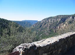
Flagstaff’s proximity to Grand Canyon National Park, about 75 miles (121 km) north of the city, has made it a popular tourist destination since the mid-19th century. Other nearby outdoor attractions include Walnut Canyon National Monument, Sunset Crater Volcano National Monument, Wupatki National Monument, and Barringer Crater. Glen Canyon National Recreation Area and Lake Powell are both about 135 mi (217 km) north along U.S. Route 89.
Fun and Fascinating Facts
- Arizona has 3,928 mountain peaks and summits—more mountains than any one of the other Mountain States (Colorado, Idaho, Montana, Nevada, New Mexico, Utah, and Wyoming).
- All New England, plus the state of Pennsylvania would fit inside Arizona.
- Arizona became the 48th state and last of the contiguous states on February 14, 1912.
- There are more wilderness areas in Arizona than in the entire Midwest. Arizona alone has 90 wilderness areas, while the Midwest has 50.
- Arizona has 26 peaks that are more than 10,000 feet in elevation.
- Arizona has the largest contiguous stand of ponderosa pines in the world stretching from near Flagstaff along the Mogollon Rim to the White Mountains region.
- Yuma, Arizona is the country’s highest producer of winter vegetables, especially lettuce.
- Arizona is the 6th largest state in the nation, covering 113,909 square miles.
- Out of all the states in the U.S., Arizona has the largest percentage of its land designated as Indian lands.
- The “Five C’s” of Arizona’s economy are: Cattle, Copper, Citrus, Cotton, and Climate.
- More copper is mined in Arizona than all the other states combined, and the Morenci Mine is the largest copper producer in all of North America.
- Billy the Kid killed his first man, Windy Cahill, in Bonita, Arizona.
- Famous labor leader and activist Cesar Chavez was born in Yuma.
- When England’s famous London Bridge was replaced in the 1960s, the original was purchased, dismantled, shipped stone by stone and reconstructed in Lake Havasu City, Arizona, where it still stands today.
- Mount Lemmon, in the Santa Catalina Mountains, is the southernmost ski resort in the United States.
- Rooster Cogburn Ostrich Ranch in Picacho, Arizona is the largest privately-owned ostrich ranch in the world outside South Africa.
- Located on Arizona’s western border, Parker Dam is the deepest dam in the world at 320 feet.
- South Mountain Park/Preserve in Phoenix is the largest municipal park in the country.
- Palo Verde Nuclear Generating Station, located about 55 miles west of Phoenix, generates more electricity than any other U.S. power plant.
- Montezuma never visited Montezuma National Monument—he was born 100 years after the prehistoric dwelling was abandoned. The monument was misnamed for the Aztec emperor when it was rediscovered in the 1860’s.
- Petrified wood is the official state fossil. The Petrified Forest in northeastern Arizona contains America’s largest deposits of petrified wood.
- Many of the founders of San Francisco in 1776 were Spanish colonists from Tubac, Arizona.
- Phoenix originated in 1866 as a hay camp to supply military post Camp McDowell.
- Chino Valley’s Fort Whipple was a U.S. Army post that served as Arizona Territory’s first capital prior to the founding of Prescott. The post was founded in January 1864, but was moved in May 1864 to Granite Creek near present-day Prescott.
- Prior to President Abraham Lincoln signing the Arizona Organic Act on February 24, 1863 to create Arizona Territory, Arizona was part of the territory of New Mexico.
- Rainfall averages for Arizona range from less than three inches in the deserts to more than 30 inches per year in the mountains.
- Rising to a height of 12,643 feet, Mount Humphreys north of Flagstaff is the state’s highest mountain.
- Roadrunners are not just in cartoons! In Arizona, you’ll see them running up to 17-mph away from their enemies.
- The Saguaro cactus is the largest cactus found in the U.S. It can grow as high as a five-story building and is native to the Sonoran Desert, which stretches across southern Arizona.
- The best-preserved meteor crater in the world is located near Winslow, Arizona.
- The Arizona Cardinals are the oldest continuous franchise in the National Football League, dating back to 1898.
- Between the years 1692 and 1711 Spanish missionary Father Eusebio Kino did more than just found missions in Arizona; he also taught many tribes the basics of agriculture and supplied them with cattle and seed grain.
- The Castilian and Burgundian flags of Spain, the Mexican flag, the Confederate flag, and the flag of the United States have all flown over the land we now know as Arizona.
- Nearly 5 million people visit Arizona’s Grand Canyon National Park each year.
- The Palo Verde is the official state tree. Its name means “green stick” and it blooms a brilliant yellow-gold in April or May.
- The saguaro cactus blossom is the official state flower. The white flower blooms in May and June, opening in the middle of the night and closing the next day—surviving only about 18 hours for pollination.
- A saguaro cactus can store up to nine tons of water.
- The State Motto is Ditat Deus, which means “God Enriches” in Latin.
- The state of Massachusetts could fit inside Maricopa County (9,922 sq. miles).
- The westernmost battle of the Civil War was fought at Picacho Pass on April 15, 1862 near Picacho Peak in Pinal County.
- There are 11.2 million acres of National Forest in Arizona, and one-fourth of the state forested.
- Tubac was the first European Settlement in Arizona (1752).
- Wyatt Earp was neither the town marshal nor the sheriff in Tombstone at the time of the shoot-out at the O.K. Corral. His brother Virgil was the town marshal.
- On June 6, 1936, the first barrel of tequila produced in the United States rolled off the production line in Nogales, Arizona.
- The Sonoran Desert is the most biologically diverse desert in North America.
- The Arizona tree frog is the state’s official amphibian.
- Bisbee is the Nation’s southernmost mile-high city.
- The longest remaining intact section of Route 66 can be found in Arizona and runs from Seligman to Topock, a total of 157 unbroken miles.
- The negotiations for Geronimo’s final surrender took place in Skeleton Canyon, near present day Douglas, Arizona, in 1886.
- Prescott, Arizona is home to the world’s oldest rodeo, and Payson, Arizona is home to the world’s oldest continuous rodeo—both of which date back to the 1880s.
- Kartchner Caverns, near Benson, Arizona, is a massive limestone cave with 13,000 feet of passages, two rooms as long as football fields, and one of the world’s longest soda straw stalactites: measuring 21 feet 3 inches.
Hiking and Touring
Some of the most beautiful country in the Southwest surrounds Flagstaff, from lush pine woods to rugged deserts. The Grand Canyon, Oak Creek Canyon, Sedona’s red rocks, Native American reservations, and a string of breathtaking national monuments are all within a short drive. Flagstaff has a number of great hiking trails.
Gateway to the Grand Canyon
There are two ways to enter the Canyon from Flagstaff. One route heads through Williams to the west and the other, much closer, takes you on a less traveled back route. At the intersection of Highway 89 and 64, travel west on 64 to Grand Canyon National Park.